Fire tower climb more technical than anticipated
By Tom French
In yet another case of a bait-and-switch weather forecast with the promise of partly cloudy skies and temps pushing 60, the late October morning broke with rain. I almost called Doug to postpone our climb of Mount Adams from near the Upper Works trailhead and historic blast furnace. Instead, he texted me saying I should bring traction devices just in case. It was supposed to clear but still be chilly at elevation. At 3,460 feet, Mount Adams is one of the higher fire tower peaks.
Another allure of Mount Adams, for me, was finding the remains of a brickyard associated with the mid-19th-century mining operation. Paul Hai, associate director at SUNY ESF’s Newcomb Campus and a guide for a recent AARCH (Adirondack Architectural Heritage) tour of the Tahawas area, described a U-shaped kiln and pug mill with a large iron artifact of arcing blades hidden in the thick wilderness. The words “iron,” “large,” “arcing,” and “hidden” was enough excuse for me.
The trailhead for Mount Adams is well marked with signage provided by the Open Space Institute 300 yards past the blast furnace along the Upper Works Road. The sun was attempting to peak through the clouds as we signed in. A note on the trail register warned of a loose floor panel on the bridge over the Hudson. Doug recounted fording the river after the bridge was washed out by Hurricane Irene.
The swing bridge is below the parking area along a relatively new trail by the Open Space Institute that connects the Blast Furnace with the old village of Adirondac.
The Open Space Institute, a national organization dedicated to protecting scenic, natural and historic landscapes, acquired the 9,646-acre Tahawus Tract in 2003 and sold much of it to New York State in 2008 except for the area of the historic Upper Works, a circular parcel around the Mount Adams Fire Tower, and a small plot at the observer’s cabin – hence allowing the OSI to create the interpretive trail in Adirondac as well as preserve the fire tower and cabin.
Because of the warning about the bridge, I let Doug traverse first. Better him than me. A plank has been placed over the questionable section, and if you accidentally step on the panel, you will know it, as I can attest from experience.
My directions to the brick kiln involved a power line. Both Doug and I assumed it would be obvious, but five minutes later we spotted Lake Jimmy and knew we’d missed it. Visions of previous fails danced in our heads.
Despite a sign, we almost missed the permanent detour around the northern edge of the lake too – a path to the left with a cairn and yellow markers. The wreckage of the old bridge can be seen through the trees and from outer space (via Google Earth).

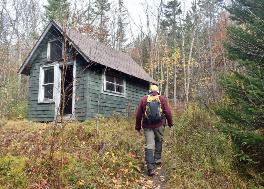
After 35 minutes from the car, we arrived at the observer’s cabin – in remarkably good shape. Evidence of recent repairs can be seen in the asphalt siding and roof. The small, one-room cabin which used to have a front porch (and two cots) is the “sole surviving example of New York’s first mass-produced observers’ cabins, designed and built for the DEC.”
The left turn to Mount Adams is a couple hundred yards past the cabin. Doug had warned me that trail was straight up, gaining 1,000 feet of elevation in just a half mile – typical of fire tower trails harkening from the days when observers took the shortest distance to the top. I was pleasantly surprised when it wasn’t so arduous that I was out of breath. Indeed, we continued to chit chat for several minutes as the trail gradually climbed.

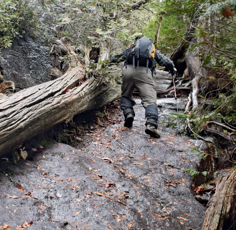
After crossing an old woods road, complete with a manmade gravel embankment, the trail rises sharply into a slide along a rock cut. Doug huddled against the face while I switchbacked from the gentler side. As part of our continuing conversation regarding modern trail standards, I asked what the solution might be here. He said, “Trust your boots.”
Above this cleft, the trail continues steeply through a rocky stream before cutting left across a contour – a last reprieve before the trail climbs relentlessly for the next quarter mile at grades pushing 50 percent and gaining 500 feet along erosional slides of leaf-covered bedrock. More than once, just as I thought we were reaching the top, the trail would swing and another upward slab of exposed anorthosite would appear. Even at the top, as the trail flattens, the fire tower does not reveal itself until after a couple turns.
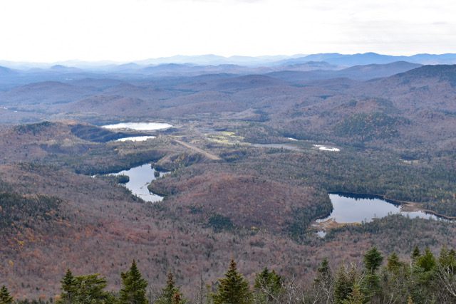
But the views from the 47-foot Aeromotor tower (different sources say it was erected in 1917 or 1922) are stunning and unique. Mount Marcy, a rounded dome from the north, is craggy and pointed. Colden is a rocky peak with elements of the Matterhorn, and the distances between the two and Algonquin look spacious. The Santanonis and Sewards dominate the western view, with Cliff, Redfield, and Allen to the east. The entire southern Adirondacks wraps for 180 degrees from Boreas to Gore and Indian Lake with the Snowys looking like they’re dreaming of being High Peaks. The map table was restored by volunteers from the Adirondacks High Peaks Foundation, who also restored the tower – complete with a duplicate of the original hand-drawn map. It identifies dozens of summits with little flags indicating fire towers.

The former National Lead titanium mine with its water-filled pits, landing strip on a tailing, and tiered benches cut into the side of one hill stands out beneath the mountain. It is now being utilized as a source for aggregate and the din of metallic pounding punctuated the day. The operation has been busy with all the flooding washouts of summer.
Although we didn’t need traction devices, cocktail ice speckled the steps of the tower. As we carefully descended the mountain, utilizing our hiking poles as third legs, we met a kid ascending. “This is much more technically challenging than I anticipated,” he said. We encouraged him to invest in poles, and I encourage you to check your treads before attempting Mount Adams.
After passing Lake Jimmy, we bushwhacked to the brick kiln. The U-shaped mound rises above the ground like a small glacial esker – the only clues to its true past a cast-iron door from the kiln and moss-covered bricks melting into the forest floor. Nearby we also found the pug mill blades, not much bigger than a school cafeteria floor mixer, where a horse- or donkey-powered rotary would have blended clay and water to the desired consistency. The round cast-iron piece lay unceremoniously in the leaves where it settled after the wooden structures around it rotted away.
We were careful not to disturb any of the artifacts, not even the bricks, in respect to their cultural and historical legacy and in recognition of our responsibility as visitors on private property to preserve the integrity of this almost 200-year-old story told on the forest floor. OSI asks that people respect and honor that history by not removing anything from the site so it can continue to serve as a place for research and teaching about an industrious past when throngs of workers noisily hustled and bustled in the now quiet forest.
Leave a Reply