Loj-to-Tahawus ski tour among best in East
By Phil Brown
A few hundred yards from the trailhead at Adirondak Loj, the Van Hoevenberg Trail makes a steep, short descent on its way to Algonquin Brook, but skiers can take a side trail to avoid this tricky pitch.
“It’s easier if we go that way,” I tell Betty Eldridge, one of our skiing partners.
“I don’t want to go the easy way,” Betty replies, a little indignant.
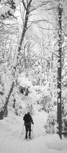
And so we shoot down the little hill, making a quick left turn at the bottom, and squeeze between the pines bordering the narrow trail. No, this would not be an easy day, but it would be about as good as it gets.
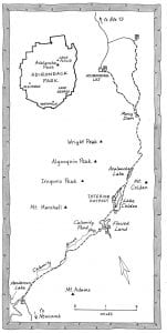
Our plan was to ski from the Loj through Avalanche Pass to the Flowed Lands and then descend by the Calamity Brook Trail to the Upper Works trailhead at Tahawus, site of a former iron mine. Somewhere along the way we would meet a fellow group of skiers doing the route in reverse. We would exchange car keys and meet later at a restaurant in Keene.
Like many backcountry skiers, I had visited Avalanche Pass on several winter outings, but I had never skied the Calamity Brook Trail. In Ski and Snowshoe Trails in the Adirondacks (see Page 6), Tony Goodwin says the descent on this trail is slightly more difficult than the return from Avalanche Pass to the Loj. He rates it as an intermediate-expert ski.
Goodwin’s book also describes the 12-mile Avalanche Pass traverse as “one of the classic trips in North America.” Think about that: We have here in the Adirondacks one of the best ski routes on the whole darn continent.
Given his enthusiasm for this trip, perhaps it’s no surprise that the organizer of our outing was none other than Tony Goodwin. He and several friends started at Upper Works. Joining Betty and me were Betty’s friend, Alan Fitzgerald, and my Explorer colleague, Jeff Schmidt.
We met Betty and Alan at the Loj a little after 8:30 a.m. and set out for Marcy Dam. Both had been to Avalanche Pass before, but they had always started from South Meadow Road and skied to the dam via an abandoned truck trail. Tony recommends this approach, since it sees little foot traffic. Jeff and I, however, usually take the Van Hoevenberg Trail on our winter excursions in the High Peaks—not because it’s a half-mile shorter but because it offers a few more ups and downs.
When we reached the dam after 2.3 miles, we paused to take photographs and admire the slides on Mount Colden and Wright Peak created by a heavy downpour in 1999. Just past the dam, we turned right off the Van Hoevenberg Trail and followed yellow markers for 1.1 miles to the lean-to at Avalanche Camps. The trail climbs gently along Marcy Brook and crosses the brook just before the lean-to. In other seasons, hikers continue straight for the half-mile climb up “Misery Hill.” But if you’re skiing, turn left at the lean-to and follow the Lake Arnold Trail a few hundred yards, then turn right onto the ski trail.
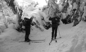
The wide ski trail switchbacks up the hill, crossing the hiking trail twice before joining it at the end of the ascent. Just beyond this point, at 3.9 miles, we arrived at the base of the Colden slide so conspicuous from Marcy Dam. The display of nature’s destructive power here is a bit eerie. The trail skirts a wall of trees unceremoniously dumped there like pickup sticks by the landslide in the 1999 storm. The broad snowfield looming overhead looks like an ideal ski slope, but no one is allowed on the slide in winter for fear that human activity could trigger an avalanche.
After passing the slide, we began a wonderful descent through the woods to the northern shore of Avalanche Lake. This part of the trail has several exciting turns and small ups and downs. The flats will help you keep your speed under control. The trail is narrow, so you have to beware of skiers and snowshoers coming your way.
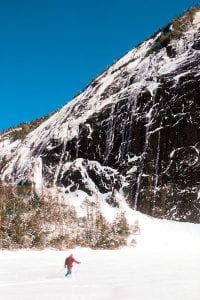
Wedged between gray cliffs that rise straight out of the water, Avalanche Lake is one of the natural wonders of the Adirondacks. We got there just as the sun was peeking over Mount Colden, so the lake was split down the middle between shadow and light. Jeff and I skied to the sunny side to wait for Betty and Alan and put on nylon jackets to fend off the wind that rips up the narrow lake. We had to wait only a few minutes, but in that time the darkness retreated 20 feet or so. It was like watching the shadow move on a sundial.
Reunited, we skied past the famous Trap Dike, a giant gash in the side of Colden, and reached the end of the lake in 10 minutes. We then got back on the hiking trail and whooshed down a small hill to a trail register where the trail splits. We turned right to go around the west side of Lake Colden to the forest ranger’s cabin. The trail wasn’t bad, but I later discovered that Tony’s book recommends leaving the trail at the register and going straight ahead, following an old phone line marked with occasional yellow ski markers, to the north end of the lake.
We tarried a while at the cabin, thinking the other group would show up soon. When they didn’t, we skied across the lake to eat lunch in the lean-to at Beaver Point, where there is a marvelous view of Mount Colden and Algonquin Peak. After lunch, we made the mistake of getting back on the hiking trail instead of skiing across the lake. The trail had a number of short but steep dips that wouldn’t bother a hiker but made lousy skiing. Then we had to remove our skis to descend a ladder to the bridge that crosses the dam at the foot of the lake.
We had taken that trail only because we thought the other group might be coming that way. Now, as we realized our mistake, we wondered if we had missed them. It was already past noon. Shouldn’t they be here by now? Should we turn back? We continued the short distance to the Flowed Lands and gazed across the broad expanse of snow. Still no sign of the others. We were on the verge of turning around when I skied to the top of a small rise and saw a herd of wool hats bobbing up and down.
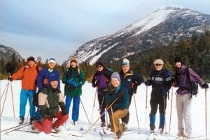
Soon we were exchanging greetings and car keys and taking photos of each other. Before parting, Tony warned us to watch out for a tree that had fallen across the Calamity Brook Trail near the state land boundary.
Having laid our fears to rest, we could relax and enjoy the scenery. In other seasons, the Flowed Lands is a popular destination, but we had the place all to ourselves. It was serene and beautiful, a frozen flatland with the spectacular backdrop of Mount Colden towering over Avalanche Pass. We took a long, last look before re-entering the woods and picking up the Calamity Brook Trail.
The trail begins with a fun downhill run. In less than a half-mile, it reaches Calamity Pond, where David Henderson was accidentally shot to death in 1848. His family erected a stone memorial beside the pond. To get to it, look for a short side trail on the right.
We soon came to several other downhill runs, separated by flat sections. On one hill, we had to stop quickly to avoid a small tree lying on the trail. Is this the one Tony meant? Since we soon reached the state land boundary, we guessed that it was. But immediately after this we encountered a much larger tree across the trail. Since it was four or five feet off the ground, I skied under it and kept going. I was still picking up speed when I hit a sharp turn to the right and then a hairpin turn to the left. The trail was still quite steep coming out of the second turn, but I didn’t have time to worry. Fortunately, it flattened out after another turn to the right. Those turns were the most challenging part of the descent.
Over the next mile, we enjoyed several other downhill runs. After crossing the brook for the third time, we skied through an open area that sustained a lot of blowdown during the storm generated by Hurricane Floyd—the same storm that created the new slides on Colden and Wright. Tony says in his book that this clearing resulted from salvage logging.
After leaving the clearing, we came to a trail junction and turned left. From here, it’s an easy ski over mostly flat terrain to the Upper Works parking lot. The last stream you pass over is the Hudson River shortly after it flows out of Henderson Lake. The mighty Hudson is about 10 feet wide at this point.
It had been an ideal day: sunny, good ski conditions, lots of thrills and not too many spills. The drive to Keene took an hour. We met Tony and his group at Monty’s Elm Tree Inn to hoist a few beers, make a few toasts and exchange promises to do it again next year.
[mappress mapid=”43″]
Leave a Reply