2 bangs for the buck. Photos by Carl Heilman II
By Phil Brown
As a photographer, Carl Heilman has captured hundreds of great views in the Adirondacks. One of his favorites is the view of Lake George from Cat Mountain, so when he suggested last winter that we ski to the summit, I jumped at the chance.
Many people ski Cat as an eight-mile round trip, following an old logging road that traverses a nature preserve owned by the Lake George Land Conservancy. Carl and I, however, left a second car at Edgecomb Pond, east of the preserve, and did an end-to-end trip of about 5.5 miles.
We also took in the view from a rustic cabin on top of nearby Thomas Mountain, a bonus well worth the extra effort. Both peaks are part of the 1,850-acre preserve, which the conservancy purchased in 2003. Both can be climbed easily on skis via old logging roads. A scenic hiking trail, opened in 2006, follows the ridge between the two summits—an ideal route for snowshoers (and perhaps adventurous skiers).
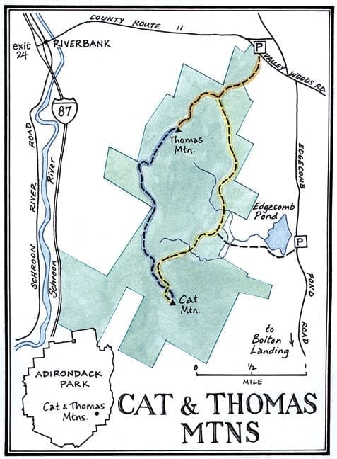
Carl and I did our trip shortly after a big snowfall. When we reached the trailhead, off Valley Woods Road in Bolton, we discovered that the parking area had not been plowed. Winter adventurers should be prepared to park along the road.
From the trailhead, whether you’re going to Thomas or Cat, you’ll start off on a logging road marked by orange disks. The trail climbs about 680 feet over 1.4 miles, but at the beginning, the road is level. When we came to the first sizable hill, we stopped to put synthetic skins on our skis to keep us from sliding backward on the ascent. We kept them on until we reached the 1,940-foot summit.
The Adirondack Explorer thanks its advertising partners. Become one of them.
At the top of the first hill, we came to an old gravel pit with green plastic tubes sticking out of the snow. The biodegradable tubes protect tree seedlings planted by the conservancy a few years ago to restore the site.
Three-quarters of a mile into the trip, we arrived at a trail junction in a clearing. If you’re going to Thomas, turn right here to stay on the orange trail. If you’re going to Cat, you should go straight, following the yellow markers.
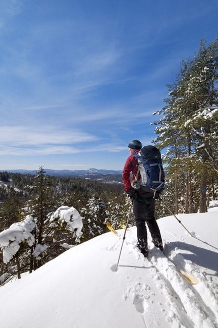
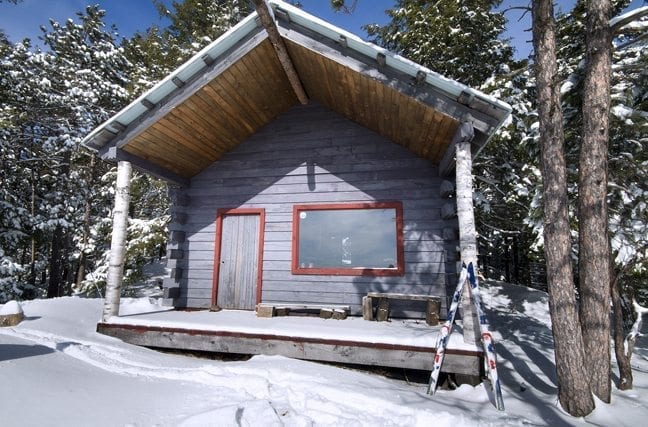
Up to this point, we had been passing through hardwoods, but from the clearing we could see snow-covered evergreens on the Thomas ridgeline. Ascending in switchbacks, we soon found ourselves amid a stand of handsome hemlocks. Finally, after 90 minutes of slow progress, we reached the top of Thomas, where a one-room cabin commands a magnificent view of the southern basin of Lake George. We looked down on Long Island and across the lake to Pilot Knob.
To the south were plumes of steam rising from factories in Glens Falls. To the west was a more appealing sight: the cliffs of Crane Mountain.
The cabin had been built by the previous landowner to help market the property to hunters. The Lake George Land Conservancy has no plans to remove the structure, though it may do so in the future. Carl and I were happy to take refuge from the cold inside the cabin, admiring the view through a picture window. We ended up spending an hour on Thomas, eating lunch and taking photos.
The Adirondack Explorer thanks its advertising partners. Become one of them.
From our perch on a couch, we could look across the valley to 1,956-foot Cat Mountain, about a mile and a half away. With the preserve map in hand, we also plotted in our minds the route of the ridge trail winding over and around various knobs and hills. For snowshoers, this 2.25-mile trail, marked by blue disks, is the way to go. For skiers, the sensible thing is to retrace your ascent route back to the junction, gliding in your own tracks, and then take the yellow trail to the summit of Cat.
Carl and I, however, are not that sensible. We thought the hiking trail would be more interesting (which it is), so we decided to ski it. The adventure began with a tricky descent from the Thomas cliff face to an overgrown logging road. We put our skins back on and left them on for the rest of the way to Cat. Laid out by Richard Hayes Phillips, the trail climbs over a series of knobs, ledges and other lookouts. No doubt the views are better in winter, when the leaves are off the deciduous trees. Many times, we could see the mountains on the east side of Lake George. At one ledge, we could see Mount Marcy, partially wrapped in cloud, and a number of other High Peaks.
“Boy, it’s one view after another,” I remarked after arriving at our umpteenth vista.
“Yeah, it sure beats the logging road,” Carl replied.
The Adirondack Explorer thanks its advertising partners. Become one of them.
Still, I don’t imagine most skiers would relish breaking trail in deep snow for 2.25 miles. Also, if you try it without skins on your skis, you’re bound to tire yourself out on the many climbs, both big and small. But if you have a pair of skins and a spirit of adventure, go for it. Just be aware that it’s more like snowshoeing on skis than real skiing. Of course, if the trail is broken, you’ll have an easier time.
It took us more than three hours (including photo breaks) to travel from Thomas to Cat. We emerged on the summit a few minutes after 5 o’clock, when the mountains across the lake were aglow in the soft, yellow light of the setting sun: Black, the region’s tallest mountain; Shelving Rock, with its cliffs seemingly hanging over the water; Sleeping Beauty, an enchanting peak set back from the lake; and the two neighbors, Buck and Pilot Knob. Also visible were Dome and Long islands and the numerous smaller islands found in the Narrows. Hunting around, we also found a lookout toward the High Peaks.
“Cat Mountain is not only one of the finest views of Lake George,” Carl said, “it’s one of the finest views in the Adirondacks.”
That’s high praise from a man who has taken tens of thousands of photos in the Adirondack Park.
But if this was an ideal time and place for taking photos, we couldn’t stay too long. We were running out of daylight and still had two miles to go to reach our car. The drop off the summit is steep enough that even with the deep snow, we picked up quite a bit of speed. After five minutes, the trail became much more gradual, and though it continued to go downhill, we couldn’t get much glide. Carl assured me that this section goes much faster if you take this route on the way up and break trail.
The Adirondack Explorer thanks its advertising partners. Become one of them.
We passed a large beaver flow filled with dark snags, crossed a stream and came to a T intersection. The yellow trail goes left, back to the preserve’s trailhead. But we turned right and followed another logging road down to Edgecomb Pond (if you take this route, you’ll need to take a left turn at another T intersection soon after the first one). When we reached the pond, we left the road to ski across the ice. Stars had begun to appear in the darkening sky, and Carl pointed out Orion’s Belt, Sirius and the North Star. An hour after leaving the summit, we were back at the car.
Our descent route is the shortest route to Cat and is often used by locals to climb the mountain. The town of Bolton owns Edgecomb Pond, (a municipal reservoir,) and the land between the pond and the preserve. If your only objective is to ski Cat, a four-mile round trip from the pond, with 915 feet of ascent, might be the best option. But no matter what route you take, you won’t be disappointed in the destination.
DIRECTIONS:
From Northway Exit 24, drive east on County 11 for about 2 miles to Valley Woods Road and turn right. The preserve parking lot is on the right just after the turn. For the Edgecomb Pond trailhead, continue on Valley Woods Road to Edgecomb Pond Road and turn right. When the pond appears on the right, look for a parking area just beyond it.
[mappress mapid=”126″]

Leave a Reply