 By PHIL BROWN
In 1989 and 1990, the state Department of Environmental Conservation drafted a preliminary list of navigable waterways, taking suggestions from its regional staffs, the Adirondack Mountain Club’s canoe-route subcommittee, and American Whitewater, a nonprofit group devoted to protecting whitewater resources.
Since the list was only preliminary, DEC planned to hold public hearings at which paddlers and landowners would have had an opportunity to argue for adding or subtracting waterways.
Because the hearings were never held, the list was never released or subjected to public scrutiny. Thus, it cannot be assumed that every waterway on the list is, in fact, navigable or that all waterways not on the list are not navigable. Nevertheless, most are thought to be navigable under the common law.
The Adirondack Explorer thanks its advertising partners. Become one of them.
With those caveats, here are the fifty-five Adirondack waterways (out of 253 in the state) that made the list.
…………………………………………………………
Ausable River
Ausable Forks to Lake Champlain
Ausable River, East Branch
• Between Route 73 bridges south and north of Keene Valley hamlet
• Keene to Ausable Forks
The Adirondack Explorer thanks its advertising partners. Become one of them.
Ausable River, West Branch
• South Meadow to Monument Falls
• Wilmington Dam to Ausable Forks
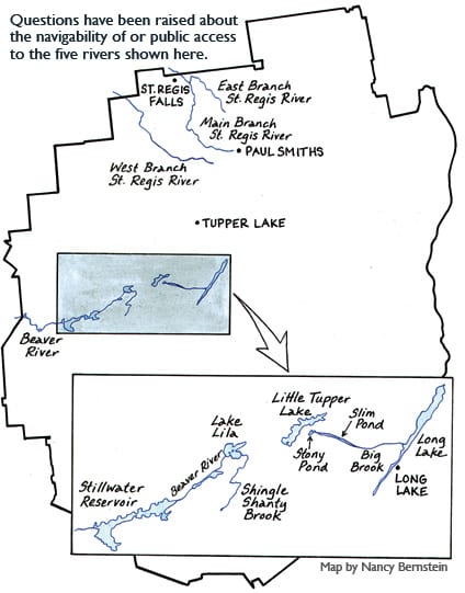
Beaver River
Lake Lila to Black River
Big Brook
Stony Lake to Long Lake
Black Creek
Black Creek Reservoir to Hinckley Reservoir
The Adirondack Explorer thanks its advertising partners. Become one of them.
Black Pond Outlet
Black Pond to Keese Mills Road
Black River
North Lake to Lake Ontario
Bog River
Adirondack Railroad tracks near Bog Lake to Round Lake Outlet
Boquet River
Beaver Meadow Brook to Lake Champlain
The Adirondack Explorer thanks its advertising partners. Become one of them.
Cedar River
Wakely Dam to Hudson River
Chateaugay River
Middle Kiln Brook to Canadian border
Deer River
Deer River Flow to St. Regis River
East Canada Creek
Powley Place to Mohawk River
Fall Stream
Vly Lake to Piseco Lake
Follensby Pond Outlet
Follensby Pond to Raquette River
Grass River, North Branch
Gleason Road to Main Branch of Grass
Grass River, South & Main Branches
Little Mountain headwaters to St. Lawrence River
Harrington Brook
Harrington Pond to Lake Lila
Hatch Brook
Pond Road to West Branch of Salmon River
Hudson River
Henderson Lake to Troy Dam
Indian River
Indian Lake to Hudson River
Jessup River
Perkins Clearing to Indian Lake
Jordan River
St. Lawrence County line to Carry Falls Reservoir
Kunjamuk River
Kunjamuk Flow to Sacandaga River
Little River
• Route 3 east of Star Lake to Aldrich Pond
• Aldrich to Brown Falls Bridge
Little Tupper Lake
Entire lake and outlet
Marion River
Blue Mountain Lake to Forked Lake carry
Mill Creek
Near Crane Mountain to Hudson River
Moose River, Main & Middle Branches
Eighth Lake to Lyons Falls
Moose River, North Branch
Big Moose Lake to Middle Branch
Moose River, South Branch
Otter Brook Road to Middle Branch of Moose
Osgood River
• Jones Pond to Osgood River and beyond
• East of Route 30 to Meacham Lake put-in
Oswegatchie River
Cranberry Lake to Ogdensburg
Oswegatchie River, East Branch
Partlow Dam to Inlet
Oswegatchie River, Middle Branch
East of Buck Pond to West Branch of Oswegatchie
Oswegatchie River, West Branch
Long Pond to Main Branch of Oswegatchie
Piseco Outlet & Spy Lake Outlet
Big Bay to Sacandaga River
Raquette River
Raquette Lake to St. Lawrence River
Red River
Moose River Plains Road to South Branch of Moose
Round Lake Outlet
Round Lake to Tupper Lake
Sacandaga River, East Branch
Lake Pleasant outlet to Hudson River
Sacandaga River, West Branch
Route 10 bridge to Shaker Place
St. Regis River, Main Branch
St. Regis Church to St. Lawrence River
St. Regis River, East Branch
Rice Brook to Main Branch of St. Regis
St. Regis River, West Branch
Little Fish Pond to Main Branch of St. Regis
Salmon River
2.5 miles above Mountain View Pond to Fort Covington
Saranac River
• Indian Carry to High Dam at Moffitsville
• High Falls Dam to Cadyville Beach
Saranac River, North Branch
Goldsmith Road bridge to Main Branch of Saranac
Schroon River
Sharp Bridge campground to Hudson River
Shingle Shanty Brook
Shingle Shanty Pond to Lake Lila
Stony Creek Ponds Outlet
Coreys to Raquette River
West Canada Creek
Indian River junction to Mohawk River
West Canada Creek, South Branch
The Flow to West Canada Creek
Woodhull Creek
Sand Lake to Forestport Reservoir

Leave a Reply