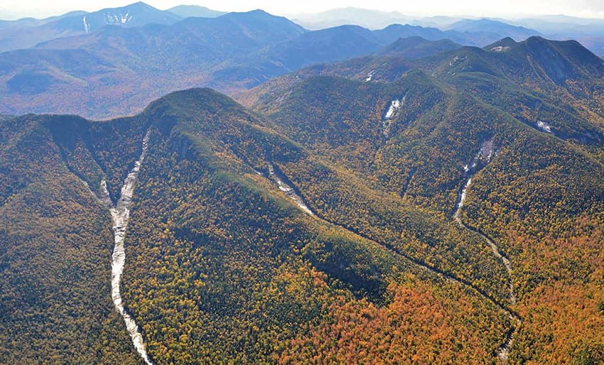
Lower and Upper Wolf Jaw mountains that
were created or enlarged by Tropical Storm Irene.
Photo by Kevin MacKenzie
Post-Irene slide guide.
Tropical Storm Irene did more than change the face of the High Peaks: it rendered The Adirondack Slide Guide by Drew Haas obsolete. Thankfully, Haas has put out a second edition of the book that includes new slides created by Irene in 2011.
The new edition follows the format of the first: it’s a softcover publication with large black-and-white aerial photos of dozens of slides, mostly in the High Peaks. All of the photos were taken in winter, when the slides (covered with snow) stand out most against the forested slopes.

By Drew Haas
The Mountaineer, 2013 (2nd edition)
Softcover, 56 pages, $14.95
Slides are long bedrock paths created when heavy rains saturate thin soils on steep slopes, washing away trees and other vegetation. They are a common sight in the High Peaks.
The Adirondack Slide Guide is a resource for those who climb slides and those who ski them, but it’s probably used more by skiers. The front covers of both editions picture skiers on summits.
Although the book identifies the general location of the slides (the mountain and aspect), it provides no directions on how to get to them. In the introduction, Haas describes The Adirondack Slide Guide as “a visual tool rather than a descriptive guidebook.” So if you want to visit a slide you’ll have to figure out how to get there. Some slides can be accessed directly from a hiking trail, but in most cases, you have to do some bushwhacking, which means you need to know how to read a topo map and use a compass (or GPS device).
When I asked Haas why he didn’t include directions, he replied, “It takes away the adventure.”
No doubt many slide aficionados prefer the book this way: the lack of directions also serves to keep away the hoi polloi.
Nor does the book describe the slides or rate their difficulty. If you’ve never climbed a slide, don’t head out alone up the Trap Dike on Mount Colden or the Eagle Slide on Giant. Hire a guide or tag along with an experienced friend, and start with something easier.
The new The Adirondack Slide Guide depicts ninety-one slides (a few are actually bedrock faces), nineteen more than the first edition. Many of the new ones were created during Tropical Storm Irene, such as the exit slide above the Trap Dike and the Cooper Kiln Slide in the Wilmington Range. In addition, several old slides were expanded by Irene. In all, seventeen of the forty-six aerial photos depict terrain greatly changed by Irene.
Haas also has broadened the geographical scope of The Adirondack Slide Guide. For example, it depicts slides on Santanoni Peak and Kilburn Mountain, two peaks (among others) not included in the first edition.
The second edition was published this past spring by the Mountaineer, the Keene Valley outfitting store where Haas works. The preface was written by Jesse Williams, a Keene Valley skiing and climbing guide. Although eight pages longer than its predecessor, it sells for the same price: $14.95. If you’re serious about climbing or skiing slides, that’s a bargain.
Incidentally, Haas may want to start working on the third edition. At least one slide—on the west slope of Dix Mountain—came down this summer after the book was published. ■